The Bicycle NSW advocacy team joined up with Inner West bike advocates for a tour of the Rozelle Interchange project site. Guided by members of the John Holland project team, we explored the edges of the mammoth construction site and gained some interesting insights into the future active transport connections.
The project to deliver the Rozelle Parklands on the site of the old Rozelle Rail Yard is moving forward fast and is due to be completed in 2024. It all sits above the enormous subterranean spaghetti junction of WestConnex tunnels connecting the M4-M5 Link, the Anzac Bridge, Iron Cove Bridge and the future Western Harbour Tunnel. You can explore the proposals here.

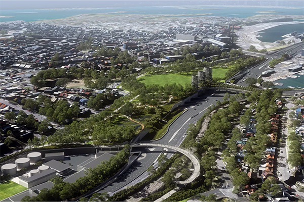
An artist’s impression of the new Rozelle Parklands, looking east towards the Anzac Bridge (Image: TfNSW)
If the project is delivered as promised, 10 hectares of open space will include full-sized sporting fields, 3000 trees, spaces for events, landscaped wetlands, playgrounds and new shared paths. Two new bridges span the City West Link, and a generous underpass below Victoria Road will create direct access to the Anzac Bridge cycleway.

A sneak peek at the Green Link Bridge that will take pedestrians and bike riders over multiple lanes of surface traffic. Unfortunately views toward the city are partially blocked by a vehicle ramp, added as a modification (just visible to the right of the photo) to prevent cars needing to wait at ground level to turn right from The Crescent towards the Anzac Bridge (Image: Bicycle NSW)

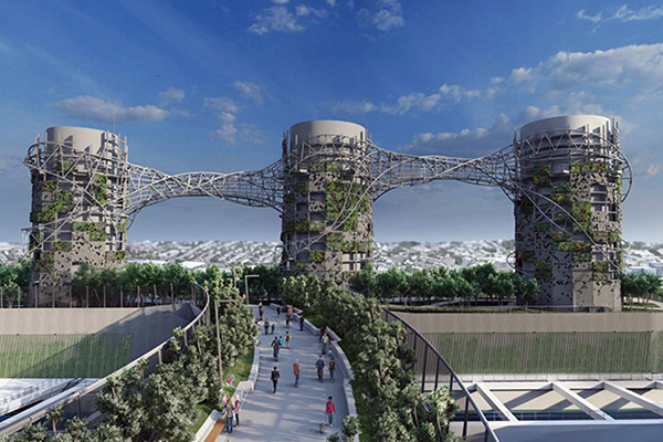
An image showing the final landscaped Green Link and the three 40m-high concrete exhaust stacks that will be wrapped with a twisting sculpture of steel, zinc and vegetation (Image: Studio Chris Fox)
The Parklands provide some compensation for a highly unpopular project rooted in twentieth-century car-first thinking, conceived to prioritise the through-travel of trucks and motor vehicles over people, ecology, community, air quality and public health.
However, we are still concerned that the reconfiguration of this huge swathe of the inner city will not deliver a truly integrated active transport network in the area. The new facilities at the Parklands must connect with the places where people live, work and play. Future-proof connections west to the Hawthorne Canal, north to Iron Cove Bridge, east to a reinstated Glebe Island Bridge and south to Glebe and Annandale are not included in the conditions of consent. Shared paths that hug the edge of wide, fast roads with awkward multistage crossings are not adequate.
Bicycle NSW and the Inner West Bicycle Coalition strongly reiterated that it is essential to claim some road space on Victoria Road for wider footpaths, a separated cycle lane and new landscaping and essential tree canopy. As set out in our June issues paper, this needs to happen as the new toll-free section of tunnel opens to ensure that the new capacity is not quickly filled up by more car trips. Temporary, 'pop-up' materials could be used in the short term while the design and funding of permanent changes can be resolved. This project is being discussed at high level at TfNSW and Inner West Council and we will keep chasing action and progress.
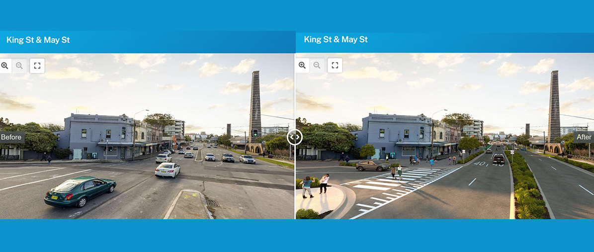
TfNSW is planning a similar project for the Princes Highway at Sydney Park Junction. The website has some useful imagery to help visualise how a traffic sewer can be transformed:

Before and after images for the King Street at the junction of May Street in St Peters, showing how road space can be reallocated to improve facilities for walking and cycling and vastly upgrade amenity for all residents and road users. (Images: TfNSW)
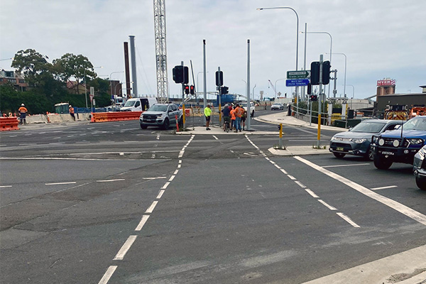
The group crossed two major intersections that highlighted the poor conditions for pedestrians and cyclists trying to access the new infrastructure. At the junctions of James Craig Road/City West Link and Victoria Road/City West Link we were forced to navigate wide slip lanes, tiny refuge islands and long waits at signals in a shadeless environment dominated by concrete and noise.

The hostile junction where Victoria Road meets City West Link (Image: Bicycle NSW)
The current infrastructure at these junctions is presumably temporary and will change as the final alignments are constructed. We asked the project team to clarify exactly how the future intersections will function for those walking and wheeling. We will continue to advocate for a better balance of movement and place that considers the safety, amenity and comfort of all road users.

The group at the Rozelle Interchange Community Information Centre – Sarah Bickford and Francis O’Neill of Bicycle NSW, John McNeil, Neil Tonkin and Bob Moore of Inner West Bicycle Coalition, Janes Challoner and Netta Kovach of TfNSW, and Elke, Carla and Gemma of John Holland (Image: Bicycle NSW)
If you live, work or bike in the area, please help us advocate for the best possible outcomes for active transport at Rozelle. Support our advocacy campaigns by joining the Bicycle NSW family today!

