An interim report from BikeSpot 2023 has revealed the worst and the best places in Sydney to ride your bike.
If you cycle around the city, then no doubt you are already aware that some of Sydney’s bike infrastructure is long overdue for an upgrade. However, not all cycleways are alike. Several routes in Sydney are more dangerous and undesirable for bicycle riders than others.
The data collected by BikeSpot has been able to identify the most dangerous spots in Sydney to cycle. Epping Road riders, you might want to take public transport!
What is BikeSpot?
BikeSpot is an interactive map that allows every Australian to say where they feel safe or unsafe while riding their bike. The project aims to create a detailed picture of where people love to ride, and where upgrades are needed to make cycling safe for everyone.
BikeSpot 2023 is a collaboration between the Amy Gillett Foundation, Australia's leading cycling safety organisation, and CrowdSpot. It is funded by the Australian Government as part of the Safe Cycling Program.
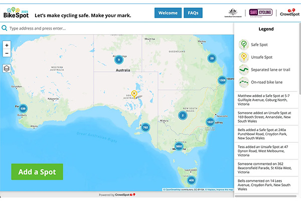
The interim data released for cities around the country collated safe and unsafe riding locations in every state (Map: BikeSpot)
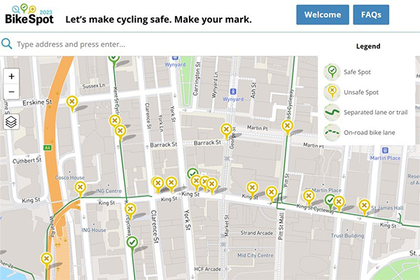
Zooming in on a dangerous area in central Sydney. Clusters of individual ‘spots’ highlight a problem area
(Image: BikeSpot)
The bad and the ugly
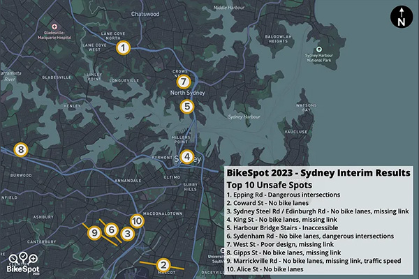
According to the interim results – which surveyed 3,000 Sydney cyclists – the most dangerous routes to ride in Sydney include a shared off-road path adjacent to Epping Road in Lane Cove in the Lower North Shore, a section of King Street in the CBD (that infamous missing link!) and the route down Coward Street in Mascot.
The interim data for New South Wales is taken from over 3,000 submissions. (Map: BikeSpot)
As many of our Members may agree - especially if they have found themselves in hectic CBD traffic, suddenly abandoned by the King Street cycleway - it’s easy to guess this list.
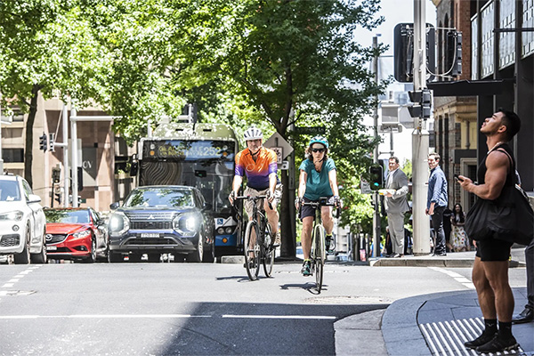
David Thomson and Sarah Gilles of Bike North, thrown into dangerous and heavy city traffic when the King Street Cycleway abruptly ends at Clarence Street. Riders heading west have nowhere to go. Bicycle NSW has been advocating for this missing link to be filled for a long time. TfNSW has promised action in 2024 (Image: SMH/Steven Siewert)
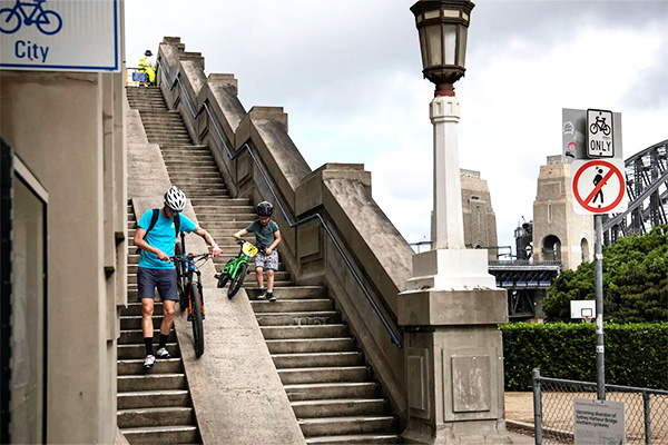
Another shocker for many bike riders is at the north end of the Harbour Bridge. Thankfully, after decades of dedicated advocacy work, construction of the Sydney Harbour Bridge Northern Access Ramp will be underway soon.
The steps have long hindered young, elderly and less able bike riders from using the most sustainable, healthy and fun mode of transport to travel between North Sydney and Sydney’s CBD and beyond (Image: Wolter Peters)
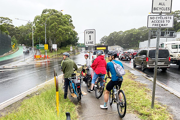
Unfortunately, it is still very hard to reach the Gore Hill cycleway from the Harbour Bridge. North Sydney Council’s plans for West Street will help fill the gap. But the dangerous crossing of the Brook Street on ramp is no closer to being fixed. Bike North and Bicycle NSW demonstrated this major pain point for riders in the Lower North Shore network on a ride with the Warringah Freeway project team. Latest update on the area here (Image: Bike North)
And the good
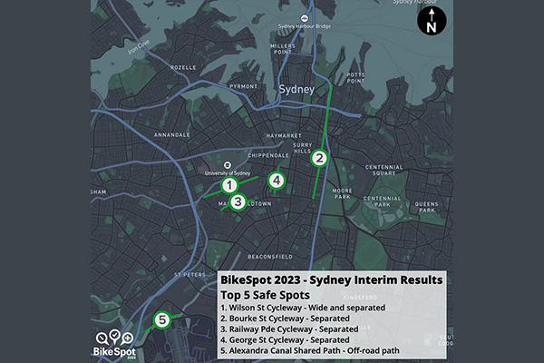
The bicycling locations that received a lot of love are where there is a top-notch separated cycleway. The Wilson Street Cycleway in Eveleigh came first on the list followed by cycleways in Bourke Street (Surry Hills), Railway Parade (Eveleigh), George Street (Redfern) and the Alexandra Canal shared path (Tempe).
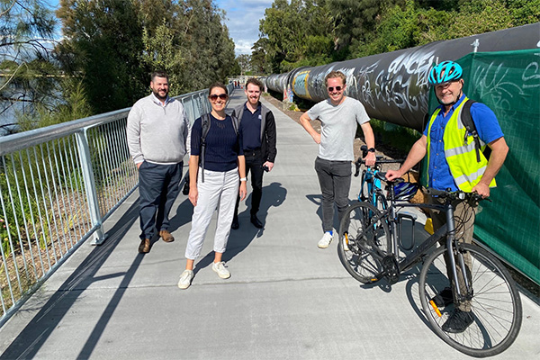
Francis O’Neill, Bicycle NSW Head of Advocacy, with staff from TfNSW on the amazing shared path along the north side of the Alexandra Canal. This path, which links Tempe Reserve with Nigel Love Bridge, is the result of a huge advocacy effort by the cycling community over many years (Image: Bicycle NSW)
The top 5 safe riding locations all coincide with a separated cycleway (Map: BikeSpot)
Safe, separated infrastructure really does roll out a ‘green carpet’ to encourage people to ride.
You can read more about the most dangerous and the safest areas to ride your bicycle in Sydney in this great Sydney Morning Herald article.
The excellent new Active Transport Link alongside the Parramatta Light Rail Stage 1 was highly regarded by BikeSpot contributors. Read more about this project here (Image: Bicycle NSW)
What happens next?
Thank you to all our friends and Members who help to populate the map! Whether you ride your bike to work, for school drop-offs or local transport, for fun or fitness, the input of every bike rider is invaluable.
The information collected by BikeSpot will be made freely and publicly available to local governments, researchers and anyone else involved in road design. Local government leaders will learn about the BikeSpot map and receive the tools and resources that enable them to deliver new and upgraded local bike routes and other infrastructure changes to make cycling safer.
BikeSpot stakeholders, Bicycle NSW and active transport advocacy groups throughout NSW sincerely hope and ask that councils and the NSW Government take the information seriously and act swiftly, responding with much needed signage, upgraded infrastructure and dedicated cycle routes.
Of course, a key issue to resolve is Sydney’s poor culture around road rage and ‘bike lash’.
“One of the most important things that need to change is driver culture. Drivers need to realise that the road must be shared,” Peter McLean, CEO Bicycle NSW explains. “This includes allowing enough space when passing bicycle riders. Under the minimum passing distance legislation, you must allow 1 metre up to 60km per hour and 1.5 metres over 60km per hour.”
Bicycle NSW works tirelessly to ensure that the NSW Government applies its excellent plans, policies and strategies to deliver the best possible outcomes for active transport.
Join Bicycle NSW to support our advocacy campaigns.

