A fantastic challenge!
Looking for a spring cycling adventure close to home? Check out the 230km Greater Sydney Bike Trail from BikeTrail.blog.
After spending a couple of years learning all the shared paths in Sydney, Garry Robinson, the founder of BikeTrail.blog, was soaking up bike culture at every opportunity.
“One evening I listened to some inspiring ladies at the bike-packing talk night at Omafiets in Redfern. The very next week I watched a selection of amazing bike adventures at The Big Bike Film Night at the Randwick Ritz. I realised it was time to complete a challenge of my own!” says Garry. “A thought bubble came to me. Why not ride around Sydney?”
Garry created a 230km loop around the outer edges of metropolitan area that pieces together some of his favourite paths. The Greater Sydney Bike Trail was born!
The very first trail around Sydney
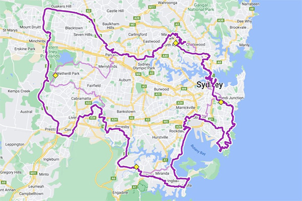
The map of the Greater Sydney Bike Trail. It is best to explore the map on a PC first. A shorter 150km route is in light purple. The 4 markers are shown as yellow diamonds. Press the Star icon to save the map in your own Google Maps account. On a phone, access in Google Maps app from the Saved tab and scroll to far right to view Saved Maps. You can then view this map while out riding and find a route. Note that community users have added variations of the main route – these are listed under ‘Rides that mainly use shared paths´. Turn these layers off to see the official routes clearly. (Image: BikeTrail.blog).
Apart from 22km of road riding in Sydney’s Eastern Suburbs, The Greater Sydney Bike Trail is all shared paths connected by some short 2-3 km sections of low-traffic back roads. It is 85% off-road.
The official start point is Mrs Macquarie's Chair opposite the Opera House. The route goes through Centennial Park, up to La Perouse, around Botany Bay, along the Menai Cycleways, past Chipping Norton Lakes, and then follows the Glenfield Rail Trail, the M7 Cycleway, Old Windsor Rd, Parramatta River Cycleway, Shrimptons Creek, Lane Cove National Park and Epping Rd. There are a lot of good things to see!
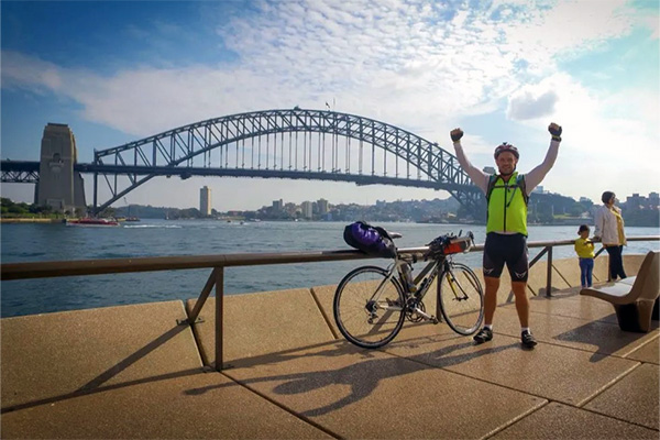
Near the journey’s end – after a crossing of the iconic Sydney Harbour Bridge cycleway
(Image: Grant Rawlinson)
A ride across the Harbour Bridge completes the classic journey. But of course, you can start the loop anywhere.
The only rule?
To go around four markers:
- Centennial Park
- Woronora bridge
- Lizard Log in Western Sydney Parklands
- Lachlan’s Line Bridge at North Ryde
You take as many days as you need to enjoy Sydney. You can skip sections on the train. You just need to pass these four places. There is a shorter 150km version but this still uses the 4 markers.
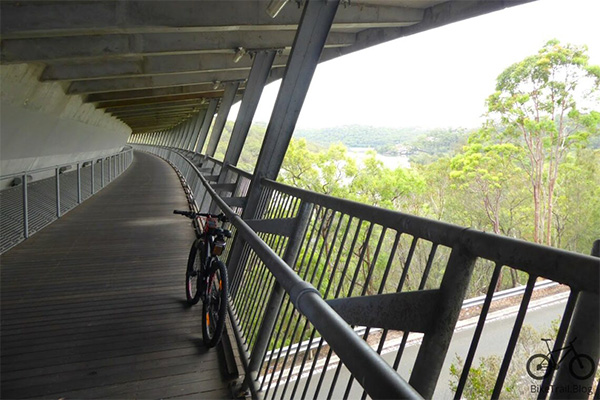
The fantastic Woronora Bridge is the southernmost marker for the Greater Sydney Bike Trail. Imagine if every major road bridge had an active transport facility like this! (Image: BikeTrail.blog)
“It felt so good to complete the journey. To turn the corner at Milsons Point and see the Sydney Harbour Bridge,” says Garry. “I had made it, 5 days, 6 train trips to get to start and end points and lots of negative thoughts were behind me. Better riders have done it in just a few days (or even one!)”.
Logistics for planning your Tour de Sydney
Trains are the best way to manage a multi-day ride. Sydney Trains allows bikes on for free and most of the stations now have lifts. Important stations for the loop are Green Square, Wolli Creek, Sutherland, Revesby, Glenfield, Edmondson Park, Rooty Hill, Bella Vista, Westmead, Meadowbank, North Ryde and Central.
Garry shows the best way to do sections of the loop as day rides using the express trains. When using the map, be sure to choose the layer ‘Greater Sydney Bike ride with trains’ for more advice.
A community of fans has built up around the Greater Sydney Bike Trail. Riders have added variations of the main route to the map – these are listed under ‘Rides that mainly use shared paths´. There is even a Facebook Group to share stories.
There are a few hotels on the trail though options are limited between Cronulla and Parramatta.
Most of the trail is smooth and suitable for any bike. However, there are quite a few bumps on the bitumen path in Chipping Norton and the brick path in Ramsgate so a gravel bike would be ideal. Garry opted for his e-bike:
“I usually tell people that Sydney bike trails are pretty flat but this ride goes through a few big dips along the waterways. I rode most of the trail using an e-bike with pedal assist. This ironed out the steep sections!”
A tourism icon of the future?
“One day all the different versions of the trail will be studied by someone important and they will set out a fixed trail, put in consistent wayfinding and fund it,” predicts Garry. “The Greater Sydney Bike Trail could be as popular as the Central West Cycle Trail!”
“This is a trail for the people of Sydney. You have a great bike city with 600km of shared paths. Enjoy them any way you can!” says Garry. “I hope to inspire you to ride around the world’s premier city and visit lots of places you probably have never seen close-up.”
The Casula Powerhouse is a multi-disciplinary arts centre, located on the banks of the Georges River – right on the Greater Sydney Bike Trail. The centre boasts 6 galleries and a 326-seat theatre. The programming draws on the strengths of its diverse community. The riverside café is great too! (Image: https://mgnsw.org.au/)
Bicycle NSW Bike Planner Sarah Bickford is a great fan of the Greater Sydney Bike Trail. “I have really enjoyed exploring western, southwestern and northern Sydney by following sections of this loop. You can get on the purple line and know it’s going to take you in the right direction, using the safest, most scenic route,” says Sarah. “I need to head up to the northwest next!”
More about BikeTrail.blog and the awesome Sydney BikeTrail Map
BikeTrail.blog is an amazing resource for planning bike trips for both recreation and transport in Sydney. Dive into the website to find the Sydney BikeTrail Map and a myriad of trail photos, ride ideas and route descriptions.
Developed by Garry Robinson over the past 5 years, the celebrated map concentrates on decent shared paths and trails. The routes are continuous, and Garry has worked hard to find the best ways to link major sections of shared path with quiet back streets and hidden paths. The map is invaluable for identifying the best safe routes for trips around Sydney and beyond. It has notched up over 1.5 million views!
Bicycle NSW interviewed Garry to find out more about his work and his passion for Sydney’s shared path network. Check out the interview here.
One more thing
It’s a good idea to join Bicycle NSW before hitting the trail to benefit from top-of-the-range insurance. Importantly, you will also support our advocacy and campaigns to make everywhere in NSW better for bike riding.


