The fantastic resources on BikeTrail.blog are no longer a Sydney secret! This treasure trove of maps, photos, ride ideas and route descriptions has become indispensable for bike riders planning trips for both recreation and transport in Sydney - and beyond.
The blog and its famous maps are the brainchild of Eastern Suburbs resident and BIKEast member, Garry Robinson.
Never too late to get back on two wheels
Garry didn’t ride a bike for over 20 years while he was busy with his career in computer programming. Then in 2017 he visited Otago in New Zealand, and he had a bit of an epiphany while riding the eponymous Central Otago Rail Trail.
Garry Robinson and his wife Fran with rental bikes, ready to hit the riverside paths of San Antonio, Texas (Image: BikeTrail.blog)
Once back in Sydney, Garry and his wife bought e-bikes and began checking out the shared paths of Sydney. And what they found was better than expected.
“When I first started thinking about Sydney trails, my head was filled with thoughts of steep hills and too many cars. Not to mention those faded white pictures of bikes on green patches on the road”, writes Garry. “After a much exploring, I can now positively say that Sydney has 1500km of scenic recreational bike trails which are definitely worth exploring”.
The paths around Salt Pan Creek and the M5 linear park were explored early on. “I really liked the ride from Wolli Creek to Riverwood using the Cooks River Cycleway to Earlwood, then back streets to Kingsgrove, then the M5 Cycleway and then down to Salt Pan Creek before finishing up at Riverwood station for the train home,” says Garry.
This bridge over Salt Pan Creek just north of the M5 was burnt by vandals in 2021. It has taken a while…. but Canterbury-Bankstown Council finally completed the replacement bridge in August 2023. (Image: BikeTrail.blog)
There is so much great riding in Sydney that most people have no idea about!
“I would look at Google Maps and Google Streetview and I found all these long paths to explore. Particularly in the west”, says Garry.
Garry then began to upload all his rides on the Sydney BikeTrail Map.
Now Garry studied for a Master of Surveying back in the 1980s and he has a deep interest in maps. Plotting all these bike trips on a map was a good way to finally make use of skills developed over the 6 years of study!
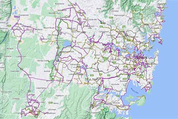
The map concentrates on decent shared paths and trails with some back road routes to link everything up. It helps riders find the best safe routes for trips around Sydney and has had over 1.5 million views.
The Sydney BikeTrail Map. It is best to explore the map on a PC first. Press the Star icon to save it in your own Google Maps account. On a phone, access in Google Maps app from the Saved tab and scroll to far right to view Saved Maps. You can then view this map while out riding and find a route (Image: BikeTrail.blog).
Layers are ordered from worst to best:
- Purple trails are the best trails
- Green trails are commuter grade and involve on-road riding, usually on quiet back streets
- Black trails are very hilly or will require good road riding skills.
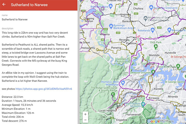
If you hover over a trail line, a short description comes up in a box with distance, elevations, and difficulty level.
An extract from the map showing a popular 22km ride from Sutherland to Narwee, with a useful route description. The rides usually start and finish at stations. Mixing bikes with train travel is a great way to avoid having to return to your starting point – and is much kinder to the environment than driving (Image: BikeTrail.blog)
Enjoyable, relaxing and scenic rides galore
The genius of Garry’s maps is that you can follow a line knowing that you are on the best practical route. It will be off-road if possible or use quiet back streets. You won’t be thrown onto the shoulder of an arterial road or motorway. If there are tricky bits, the description will warn you.
Unlike Google Maps. Google’s dark green lines that indicate cycleways are often broken and unconnected - and many are actually on major roads.
Before putting a route on the Sydney BikeTrail Map, Garry rides the route to check out possible connections to shops, stations, and other destinations. His main rule for whether a route gets a purple grading is “would I take a teenager (or my wife!) on this route?”
The routes are continuous, and Garry has worked hard to find the best ways to link major sections of shared path.
“When planning a trip on Google Maps, I found a good trick is to look for schools as there are usually safe crossings over major roads near schools,” says Garry. “Another trick is to look for cul-de-sacs that can be linked together to form quiet on-road connections.”
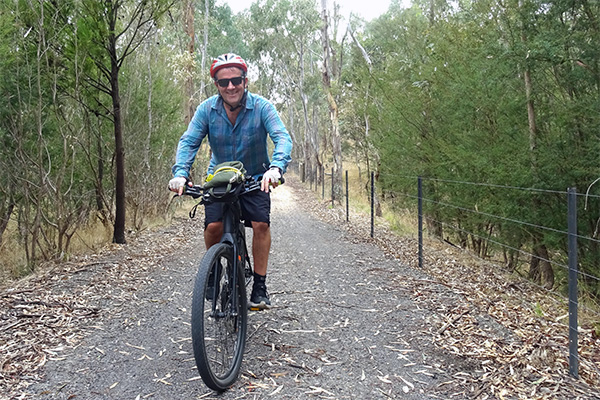
Happy days exploring on an e-bike. Garry has now mapped out the ultimate Sydney challenge – the 220km Greater Sydney Bike Trail. Head here to find out more. (Image: Garry Robinson)
“I highly recommend planning a route carefully before setting off. The Sydney BikeTrail Map is a great starting point, but there are other apps that will help. Keep an eye on detours, construction projects and the weather and adjust the trip as necessary. And ride on Sunday if you need to scope out a new route – it is so much quieter and safer.”
Garry’s favourite bit of the network?
“I love heading out to the western suburbs. There is such a density of good rides there – in places you can go for 40km without stopping at a traffic light. I also really enjoy some of the trails in the northwest, around Bella Vista, the Ponds and Small Creek”.
Bicycle NSW spent a great day touring Western Sydney’s brilliant paths with CAMWEST advocates in 2022 – read about it here.
The worst bits? “Every time I try to head into pretty much any town centre,” laments Garry. “And I would say that the Hurstville area in Georges River is the biggest black hole for cycling infrastructure in Sydney.”
Before you go….
Would you like the biking infrastructure in every part of NSW to be up to scatch? Make sure you join Bicycle NSW to support our advocacy and benefit from top-of-the-range insurance and a myriad of member benefits!


