Bicycle NSW recently made the trip to the site of Western Sydney International (WSI) to learn more about what is happening in the area. And very importantly - to understand if the multiple projects underway are delivering the very best outcomes for active transport.
Visit the airport site on two wheels - a recommended day out!
The airport Experience Centre is a long way from public transport. Most people drive, and the How to Get There instructions certainly assumed we would. But as multi-modal transport advocates who enjoy a long bike ride, we looked for a more interesting transport option!
The Northern Road and Bringelly Road have recently been upgraded to support the development of the Badgerys Creek area. There is now a high-quality shared path adjacent to the road that stretches from Kingswood to Leppington. BikeTrail.blog has some good maps and trail notes to help you plan bike rides in the area.
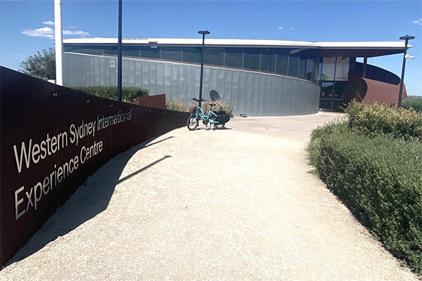
The Experience Centre sits at the halfway mark of the ride, about 17km from both Kingswood and Leppington. You do need to leave the Northern Road shared path and ride on the road for a short distance to enter Eaton Road but the road shoulder is wide and comfortable. The centre is open to the public from 10am-4pm, Saturday to Wednesday. There are interactive displays, information about the airport and a view out over the enormous construction site. The bike racks are good too! (Image: Bicycle NSW)
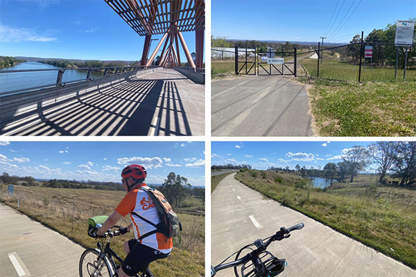
Starting from Penrith, we rode across the beautiful Yandhai bridge and along the Nepean River to the M4. Then across the river and through the leafy suburb of Glenmore Park where a track follows a series of lakes. Once on Northern Road’s smooth, concrete shared path, it is a long straightforward leg burn to Leppington Station and an express train back to Sydney. This is still a mostly rural trip and the scenery is quite bucolic. Catch it before it changes!
The Yandhai Nepean Crossing on the fabulous 7km loop River Walk in Penrith; the Warragamba Pipeline corridor crosses the Northern Road and offers tantalising potential for a long-distance walking and cycling trail into the foothills of the Blue Mountains; picturesque paddocks to the west of the Northern Road shared path
(Images: Bicycle NSW)
Thanks to Rob Kemp of Bicycle User Group CAMWEST for coming on the ride. CAMWEST has campaigned over many years for more active transport infrastructure in Western Sydney and we so appreciate their contributions to making NSW better for bike riding.
The impressive vision emerging from the paddocks
The airport is located approximately 50 km from Sydney’s central business district, near the once-sleepy village of Luddenham. The 1,780ha site is double the size of the existing Kingsford Smith Airport. Long-standing planning restrictions mean that there is little residential development in the area, so curfew-free flights will be allowed.
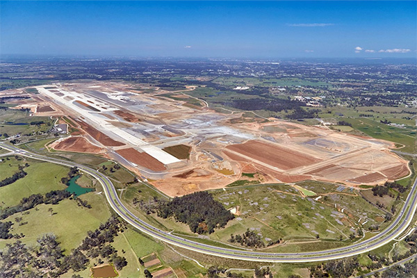
You have to get up high to appreciate the scale of the development! This photo is from late 2021 when 75% of the bulk earthworks had been completed. Runways, taxiways and the start of the terminal can be clearly seen, as can the upgraded Northern Road. (Image: Acciona)
The airport is on track to welcome its first passengers in 2026. It will be a similar size to Adelaide Airport, able to handle 10 million passengers a year. The airport has been designed to grow to 82 million passengers annually by the 2060s. The aim is to serve Western Sydney’s fast-growing and diverse population by expanding flight options to the Asia Pacific region. And there will be a lots of cargo flights, whisking fresh produce from NSW to booming markets overseas.
This is a carbon-inducing mega-project at a time when governments need to steer us to a Net Zero future. However, there is no doubting the potential for economic growth, regional transformation, new housing and jobs. And it is hard not to be impressed by ambitious vision for Western Sydney.
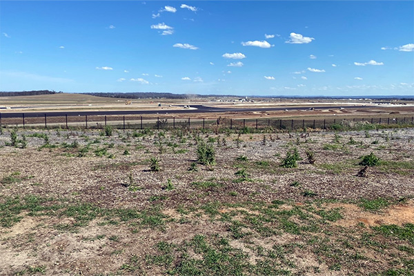
The view over the new runway, now with its asphalt top, from the Experience Centre in late 2023. Visitors to the Experience Centre can watch firsthand the vision for the airport come to life (Image: Bicycle NSW)
In 2019, it was announced the airport would be named Nancy Bird Walton Airport. Known as 'The Angel of the Outback', Nancy Bird was a trailblazer for women in aviation. Nancy wanted to fly almost as soon as she could walk. In 1933, at the age of 18, she took flying lessons at Sir Charles Kingsford Smith’s new pilots' school, and by 19 years of age she had a commercial pilot’s licence and bought her first aircraft. Nancy Bird died in 2009 and her family are thrilled that her legacy has been recognised.
A planning update at the Experience Centre
The WSI Community Engagement Officer Vicki Luff arranged for us to meet the project’s planning team for an update on the site layout and the future vision. Of course, we were very interested to hear what is planned for people traveling to and around the airport by bike.
The Western Sydney Airport - Airport Plan was last updated in 2021. This is transitional document. The Stage 1 development will include a 3.7 kilometre runway, an integrated domestic and international terminal, substantial cargo facilities, car parking and a light industrial precinct.
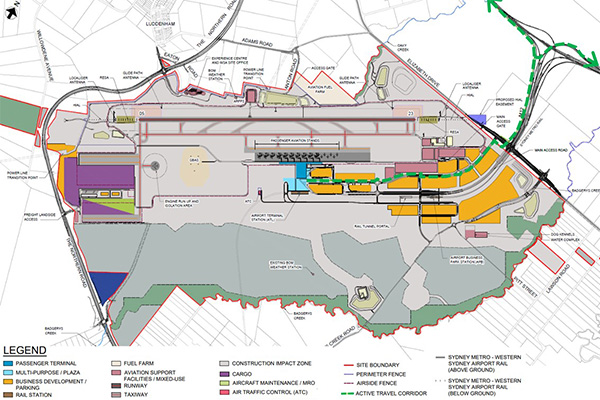
The current approved airport site master plan shows not only what will be built, but also what may be built subject to regulatory and other approvals. The 75,000 sq.m airport terminal building is huge but looks tiny on this plan! The active transport link to the M12 in highlighted as a dashed green line (Image: WSI/Bicycle NSW)
The terminal building will be about 75,000 sq.m. For comparison, the T3 terminal at Sydney Airport is 78,000 sq.m.
An integrated terminal serving both international and domestic/regional passengers is more efficient because it allows the airport to ‘swing’ certain airport facilities, such as baggage handling and security. This enables the total estimated terminal space requirement to be less than would be required with separate domestic and international terminals.
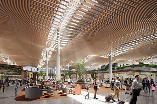
Inside the terminal building. Building on the competition and reference design by Zaha Hadid Architects and Cox Architecture, Woods Bagot’s “design encapsulates the sense of place and qualities of the Western Sydney region for a compelling journey experience through the landside, terminal and airside transitions” (Image: Woods Bagot)
Drone footage is shared regularly with the community. Head to the Western Sydney International Facebook page to see the latest video showcasing the rapid progress on site.
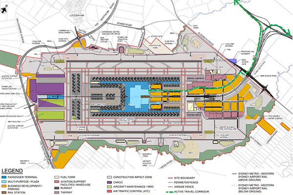
The first runway is expected to reach capacity at around 37 million passengers a year. The Airport Plan has been developed on the assumption that a second runway will be built, and the airport terminal massively expanded over the next 4 decades.
The long-term layout to handle an 82 million annual passengers (82MAP) (Image: WSI/Bicycle NSW)
Infrastructure for active transport
The Airport Plan prescribed that pedestrian and cycle access will be included in the terminal and ground transport precincts and parking areas.
An Active Transport Link will be built to connect the M12 shared path (more about this below!) with the terminal building. The route of the shared path is shown on the plan in a green dashed line. Bike riders will be able to cruise right to the terminal entrance plaza. A large bike storage shed is proposed adjacent to this pedestrianised area. We were assured that bikes would be parked closer to the front door of the terminal than any cars – an excellent application of the Road User Hierarchy.
The development control plan (DCP) for the business park development will mandate end-of-trip facilities and high levels of parking for bikes. The team is currently drafting a Sustainable Travel Plan which will focus on airport staff and business park workers.
More future connections in and around the airport
We raised concerns about the lack of active transport connections to developments south of airport. Bike riders heading toward Leppington and Narellan, and the future Aerotropolis and Bradfield City Centre, will have to leave the airport site on the east side and follow the M12 shared path to the Northern Road. This is a very long detour that will discourage workers on the Camden side from riding to the site.
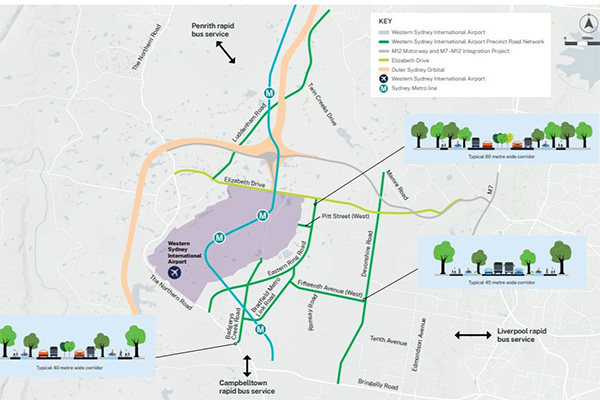
So it is good to see that Transport for NSW has recently consulted on a future Precinct Road Network. The outline plan is for seven key corridors that will provide access to Western Sydney International. They will assist movement around surrounding communities, as well as within the precinct itself. Thinking is still at a very early stage, but it is encouraging to see that the corridor cross sections for each road are generous and include fully separated bike infrastructure.
A map showing the seven road corridors under investigation for future construction or expansion. Note the cross sections showing fully separated bike paths (Source: Transport for NSW)
In the future, access to the airport should be possible via Pitt Street. This is also talk of a walking and cycling route along the Green Grid corridor of Badgerys Creek. This will allow more direct – and much more scenic – trips from the south.
The M12 motorway shared user path
Construction of the new toll-free M12 is well advanced. The 16-km motorway will connect the Northern Road with the M7. A major spaghetti junction just north of the airport site provides connections into the terminal.
A shared cycling and walking path along the entire alignment is a key feature. The path will incorporate future links to the creeks flowing through the area to create a network of Green Grid corridors that will support health, wellbeing, biodiversity and tree canopy as the region’s population grows.
By combining this path with the M7, Bringelly Road and Northern Road shared paths, Western Sydney’s bike riders will have some great new options for long loop rides. And of, course, it will be possible to reach the employment opportunities in and around the airport from many residential areas without driving. A great win for health, equity, and household budgets.
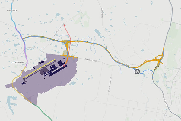
A map showing the location of the M12 corridor. The shared user path is in blue, with fine clue lines indicating future Creekside paths heading north and south. There is more information about the project on the interactive portal. Note the direct route through the Western Sydney Parkland to bypass the M7/M12 intersection
(Image: TfNSW)
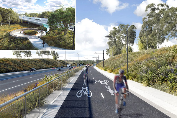
The shared path is wide with good lighting. The landscape plan has generous planted medians to separate the path users from the traffic lanes and ambitious tree canopy targets. Six rest areas (inset) will offer shade, drinking water and benches to weary travellers. Aboriginal and non-Aboriginal heritage can be explored through interpretive artworks and signage (Image: TfNSW)
At the eastern end of the M12, the shared path bypasses the noisy concrete intersection with the M7. It will take a scenic route through a section of the Western Sydney Parklands which has long been difficult to access. Bike riders will pass the Mirror Dam on beautifully designed raised board walks. Hopefully some images of what is to come will be online soon.
The Mirror Dam Cycleway promises to be a fantastic recreational facility. However, Bicycle NSW is very concerned about this section of the M12 cycleway. No lighting is proposed. This route will not feel safe at night - which is after 5pm in the winter. And there is no alternative safe route for residents and commuters riding between the M12 and M7 shared paths. This gap will prevent many commuters from using a bike for their trip.
We have learnt that conduit will be installed to facilitate the addition of lighting in the future, and we will continue to advocate for lighting to be part of the project from the outset. We have urged the projects team to investigate the many sensor-controlled lighting systems that are wildlife-friendly.
The Western Sydney Airport Metro
Construction teams are also very busy along the 23-km route of the Sydney Metro – Western Sydney Airport line. The city-shaping project, from St Marys in the north to the new Aerotropolis, will connect travellers from the airport to the rest of Sydney’s public transport system. There are 6 stations in the first phase, linking new and existing residential areas with future job hubs. An extension south towards Leppington is now being mooted. It is hoped that the metro will provide a major economic stimulus for Western Sydney, supporting more than 14,000 jobs during construction.
It is not all good news.
The construction of new roads and railways offers great opportunities to build cycleways. Governments can leverage the upheaval and investment to add a few extra metres to the project corridor. Although this happened 20 years ago when the M7 and Gore Hill Freeway were built, later projects forgot about the needs of people outside cars.
In 2021, Transport for NSW published the Providing in Walking and Cycling in Transport Projects Policy to ensure that ALL infrastructure projects incorporate excellent active transport infrastructure.
The new Parramatta Light Rail Active Transport Link is fantastic. The concept designs for the East-West Pedestrian and Cycling Link (EWPCL) alongside the Metro Southwest from Sydenham to Bankstown are very encouraging. We assumed that the policy was well-embedded in contemporary planning processes, and a shared path would automatically be part of the Western Sydney Airport metro project.
Unfortunately, it isn’t. Bicycle NSW has scoured the public documents and tried to find out more from decision makers and the project team. But it seems the opportunity to provide active transport links to the new stations and along the line has been ignored. We have written to the Minister and senior staff at Transport for NSW to lobby for its inclusion. Of course, it would be much easier to build a shared path now, while the contractors are on site.
We are still waiting for a response and will update our friends and Members when we learn more.
Are there more projects in the pipeline?
The airport is a catalyst for a huge range of projects underway in the Western Sydney Airport precinct. An interactive map provides links to more information about the project discussed and many others in the area.
The scale of the development and the long timeframes involved make for a very complex planning process. We fear that some projects are proceeding in silos, with team members unaware of what is happening nearby.
Bicycle NSW will continue to remind stakeholders and decision makers that it is essential to keep a very close eye on the progress of overlapping and contiguous projects to ensure good outcomes for everyone in the community – especially those trying to move around on two wheels.
One more thing….
Bicycle NSW works hard to ensure that huge NSW Government investments in infrastructure deliver the best possible outcomes for active transport. Join Bicycle NSW to support our advocacy campaigns.

